
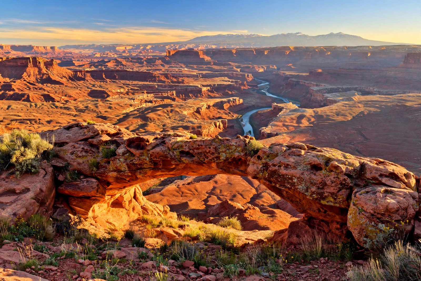
There is a place in southeastern Utah where the earth looks like it has been sliced open to show its insides. Layer upon layer of red, orange, and cream-colored rock drops away into canyons so deep and wide that the far rim seems to belong to another world. This is Canyonlands National Park, the largest national park in Utah and, somehow, one of the least visited. While crowds pack into nearby Arches National Park, Canyonlands waits quietly next door, offering the same red-rock drama with far more room to breathe.
If you love wide-open desert, big skies, and the feeling of standing somewhere genuinely wild, Canyonlands deserves a place at the top of your Utah list. This guide covers everything you need to plan a visit: the park’s four very different districts, the best hikes for every fitness level, the right season to go, and the practical details that make the difference between a great trip and a frustrating one.
Why Canyonlands Is Utah’s Great Hidden Gem
Canyonlands was established as a national park on September 12, 1964, when President Lyndon B. Johnson signed the law that set it aside for the American people. It protects about 337,598 acres of canyon country in southeastern Utah, near the town of Moab. That makes it the largest national park in the state, bigger than Arches, Bryce Canyon, Capitol Reef, and Zion.
And yet it stays remarkably quiet. The park’s rugged layout is part of the reason. Two great rivers, the Colorado and the Green, meet near the center of the park and carve it into separate districts with no roads connecting them. You cannot simply drive through Canyonlands the way you might drive through other parks. Each district is its own trip, and most visitors see only one of them. That is exactly what keeps the place feeling wild.
The other reason is that Canyonlands asks a little more of you. There are fewer paved roads, fewer services, and long stretches where you will not see another person. The reward is solitude, dark night skies, and views that have not changed much since the first people walked this land thousands of years ago. If that sounds like your kind of trip, you are in the right place.
Canyonlands at a Glance
Before you start planning, here are the basics worth knowing:
- Established: September 12, 1964
- Size: About 337,598 acres (roughly 527 square miles)
- Location: Southeastern Utah, near Moab, across San Juan, Wayne, Garfield, and Grand counties
- Districts: Island in the Sky, The Needles, The Maze, and the rivers (the Colorado and Green)
- Nearest town: Moab, Utah, about 30 to 40 minutes from the Island in the Sky entrance
- Managed by: The National Park Service
- Night skies: Certified as an International Dark Sky Park, with some of the darkest skies in the national park system
The park’s human story runs deep. Ancestral Puebloan people and earlier cultures left rock art across the region, including the remarkable Great Gallery in Horseshoe Canyon, where life-sized painted figures have watched over the canyon for thousands of years. Later, ranchers and cowboys worked the same country. In the 1950s, Arches superintendent Bates Wilson began pushing to protect the canyonlands, and his efforts, backed by conservationists and the National Park Service, led to the park’s creation in 1964. The park was expanded in 1971 to include Horseshoe Canyon and its rock art.
The Four Districts of Canyonlands
Understanding the districts is the single most important part of planning a Canyonlands trip. The Green and Colorado Rivers divide the park into three land districts, and the rivers themselves form the fourth. No roads join them, so plan on one district per day.
Island in the Sky: The Easy Introduction
Island in the Sky is a broad, high mesa wedged between the two rivers, and it is the district most visitors see first. It sits roughly 40 minutes from Moab via Utah Highway 313, and it is the most accessible part of the park, with paved roads, short trails, and overlooks that deliver enormous views for very little effort.
Stand at Grand View Point, at the southern tip of the mesa, and you can see for miles in every direction: the Needles in the distance, the La Sal Mountains on the horizon, and the canyons of the Colorado River far below. Mesa Arch, a short walk from its trailhead, is the park’s most photographed spot, especially at sunrise, when the rising sun lights the underside of the arch a fiery orange. Other easy stops include Upheaval Dome, a strange crater-like feature that geologists still debate, and the Green River Overlook. If you have only one day in Canyonlands, spend it here.
The Needles: The Hiker’s District
Southeast of the Colorado River lies the Needles, named for the colorful spires of red-and-white banded sandstone that rise from the canyon floor. This is the district for people who like to hike. Trails wind between the spires, through narrow slot canyons, and across grassy meadows that feel hidden from the rest of the world.
The Needles is reached by Utah Highway 211, about 90 minutes from Moab or an hour from Monticello. The visitor center here is seasonal, and the district has a wilder, quieter feel than Island in the Sky. Backpackers love the Needles, and its campgrounds and backcountry routes are popular with people planning multi-day trips. If you want to walk among the formations rather than look at them from above, this is your district.
The Maze: For Experienced Adventurers Only
West of the rivers lies the Maze, one of the most remote and challenging areas in the entire national park system. It is a labyrinth of slot canyons that can confuse even experienced navigators, and reaching it takes hours of driving on rough dirt roads. The National Park Service is clear that the Maze is not a place for first-time visitors: you should be prepared for self-rescue, carry plenty of water, and know how to navigate canyon country.
For those with the skills and preparation, the Maze offers something almost no other park can: true solitude in a landscape that feels untouched. The detached Horseshoe Canyon unit, managed as part of the Maze District, holds the Great Gallery, one of the finest collections of ancient rock art in North America. The hike to the Great Gallery is about seven miles round trip, reached by a long dirt road, and it is one of the great cultural experiences in the Southwest.
The Rivers: The Colorado and the Green
The fourth district is the rivers themselves. The Colorado and Green Rivers meet at the Confluence near the park’s center, then flow on together through Cataract Canyon, where the water turns into some of the most powerful whitewater in the Southwest. River trips through Canyonlands, whether a calm flat-water float or a multi-day whitewater expedition, are one of the great ways to see the park from below. Permits are required, and most visitors go with a licensed outfitter based in Moab.
The Best Hikes in Canyonlands
Whatever your fitness level, Canyonlands has a trail worth your time. These are the standouts, all verified against current National Park Service itineraries and trail guides.
Mesa Arch Trail (Island in the Sky)
The Mesa Arch Trail is an easy 0.6-mile loop, and it leads to one of the most beautiful views in Utah. The arch sits on the edge of a cliff, framing the canyons and the La Sal Mountains beyond. Sunrise is the famous time to be here, when the light sets the underside of the arch glowing, but it is also the most crowded time, so arrive early. If you only do one hike in Canyonlands, make it this one.
Grand View Point Trail (Island in the Sky)
This easy 1.8-mile round-trip trail follows the rim from the Grand View Point parking area to the southern tip of the mesa. The views open up with every step, and at sunset the whole landscape turns gold and rose. It is flat, family-friendly, and one of the best short walks in the park.
Chesler Park Loop (The Needles)
The Chesler Park Loop is the signature hike of the Needles District, a strenuous loop of roughly 10 to 11 miles that takes most hikers at least five hours. The trail climbs through the spires, drops into a hidden grassy park ringed by rock towers, and threads through a narrow slot canyon called the Joint Trail. It is a full day, it is hard work, and it is unforgettable.
Druid Arch Trail (The Needles)
Druid Arch is another serious day hike, about 10.4 miles round trip from the Elephant Hill trailhead. The trail crosses slickrock and a ladder climb before reaching a massive stone arch that looks, fittingly, like a monument from an ancient temple. Allow four hours or more, carry plenty of water, and start early.
Horseshoe Canyon to the Great Gallery (The Maze District)
This seven-mile round-trip hike descends steeply into Horseshoe Canyon and passes several rock art panels before reaching the Great Gallery, where more than 80 painted figures, some of them seven feet tall, have survived for thousands of years under a rock overhang. It is illegal to touch or disturb rock art, and visitors should admire it from the trail. The trailhead is reached by a long dirt road, so allow a full day.
When to Visit Canyonlands
Spring and fall are the best seasons for Canyonlands. From March through May and September through November, daytime temperatures are comfortable for hiking, the light is beautiful, and the crowds are thinner than in summer. Wildflowers bloom in spring, and autumn brings clear skies and crisp air.
Summer is hot. Daytime temperatures in the canyons regularly climb past 100 degrees Fahrenheit, and there is very little shade on the trails. If you visit in summer, hike early in the morning, carry far more water than you think you need, and save the afternoons for scenic drives and overlooks. Winter is quiet and beautiful, with cold nights and the chance of snow, and the Needles visitor center closes for part of the season, so check conditions before you go.
One more reason to consider a spring or fall trip: the night sky. Canyonlands was certified as an International Dark Sky Park in 2015, and on a clear, moonless night the Milky Way stretches overhead in a way that most Americans never see from home. Ranger-led stargazing programs run in the warmer months, and even an unguided evening at an overlook is worth staying up for.
Where to Stay and How to Get There
Most visitors base themselves in Moab, a friendly desert town with hotels, restaurants, grocery stores, and tour outfitters. From Moab, Island in the Sky is about a 40-minute drive via US Highway 191 and Utah Highway 313, while the Needles is about 90 minutes via Highway 191 and Utah Highway 211. The Maze requires a much longer drive on dirt roads, and Horseshoe Canyon is about two and a half hours from Moab.
Inside the park, campgrounds are available at Island in the Sky and the Needles, and backcountry camping requires a permit. Sites fill up in the busy seasons, so reserve ahead when you can. There are no lodges, restaurants, or gas stations inside Canyonlands, so fill your tank and stock up on food and water in Moab before you head in. Cell service is limited or nonexistent in much of the park, so download offline maps before you go.
Practical Tips for a Safe Visit
Canyonlands is a desert, and the desert does not forgive carelessness. These are the rules that matter most:
- Carry water. Bring at least one gallon per person per day, and more for long hikes. There is no reliable drinking water on most trails.
- Respect the heat. Hike in the morning, rest in the shade during the hottest hours, and know the signs of heat exhaustion.
- Stay on trails and slickrock. The dark, crusty soil between plants is living biological soil crust, and a single footstep can damage it for years. Walk on rock or in washes.
- Never touch rock art. Oils from your hands damage ancient paintings, and disturbing cultural sites is against the law.
- Check conditions. Flash floods can strike narrow canyons after distant rainstorms, and dirt roads to the Maze and Horseshoe Canyon can become impassable when wet. Ask at a visitor center before you go.
- Permits matter. Backcountry camping, river trips, and four-wheel-drive routes like the White Rim Road require permits. Plan ahead.
The National Park Service publishes current conditions, itineraries, and permit information on its official Canyonlands pages, and it is worth checking them before every trip. Conditions in the desert change fast, and the rangers are your best source for what is open, what is safe, and what to skip.
Frequently Asked Questions
How many days do I need for Canyonlands National Park?
One full day is enough to see Island in the Sky well, including Mesa Arch, Grand View Point, and a short hike or two. Two or three days let you add the Needles and a longer hike. A week gives you time for backcountry routes, a river trip, and the Maze if you are experienced.
Can I visit more than one district in a day?
For most visitors, no. The districts are not connected by road, and the drive between Island in the Sky and the Needles takes well over an hour each way. Plan on one district per day.
Is Canyonlands good for families with kids?
Yes, especially Island in the Sky. The Mesa Arch and Grand View Point trails are short and easy, and the overlooks are spectacular without any hiking at all. Keep children close at unfenced overlooks, carry extra water, and skip the long desert hikes in summer heat.
Do I need a four-wheel-drive vehicle?
Not for the main paved roads and overlooks in Island in the Sky and the Needles. You will need a high-clearance four-wheel-drive vehicle, and a permit, for backcountry routes like the White Rim Road and the drive into the Maze.
What is the best time of day to photograph Mesa Arch?
Sunrise. The sun rises directly behind the arch and lights its underside a glowing orange. Arrive at least 45 minutes before sunrise in spring and fall, because photographers gather early and space at the arch is limited.
Related reading
Keep exploring America’s desert Southwest with these guides from Trending 4:
- Antelope Canyon, Arizona: Slot Canyon Guide
- Valley of Fire State Park, Nevada: Complete Guide
- White Sands National Park, New Mexico: Gypsum Dunes Guide
Sources: National Park Service, Canyonlands National Park (nps.gov/cany); National Park Service trip itineraries (nps.gov/cany/planyourvisit/itineraries); National Park Trust, Canyonlands National Park (parktrust.org).