
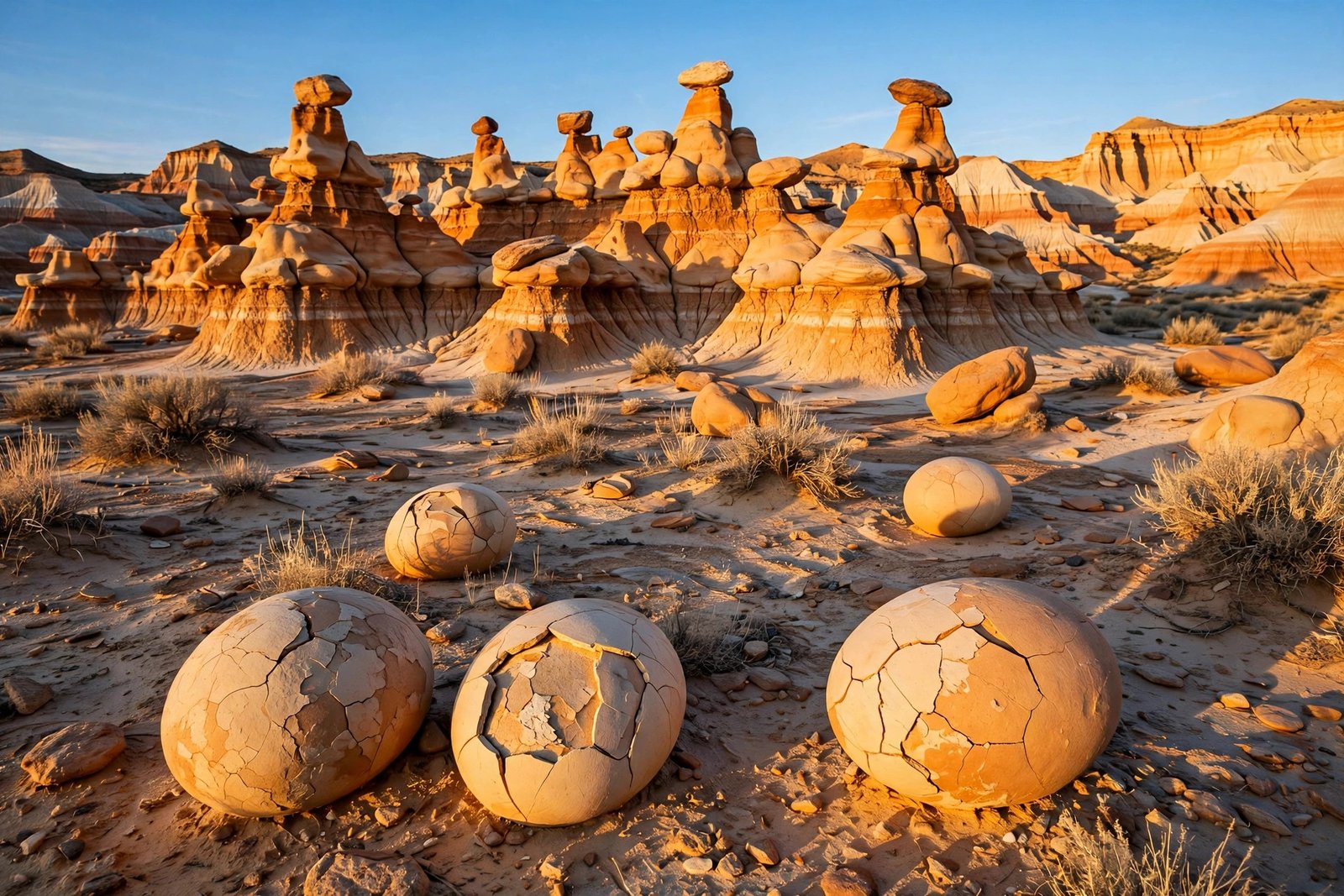
There is a place in northwestern New Mexico where the ground looks like another planet. Strange towers of rock rise from rolling clay hills. Egg-shaped boulders lie cracked open on the desert floor. Slender stone wings stretch toward the sky, and petrified logs — trees turned to stone tens of millions of years ago — lie scattered through the washes. There are no paved roads, no visitor center, no marked trails, and no crowds. This is the Bisti Badlands, one of the most otherworldly landscapes in America, and one of its best-kept secrets.
Part of the larger Bisti/De-Na-Zin Wilderness, the Bisti Badlands cover a remote stretch of high desert in San Juan County, about 36 to 40 miles south of Farmington, New Mexico. The wilderness is managed by the Bureau of Land Management and protects roughly 45,000 acres of eroded badlands, colorful hoodoos, and fossil-bearing formations dating to the Late Cretaceous period. For hikers, photographers, and anyone who loves wild places, it offers something increasingly rare: a landscape you can explore on your own terms, with no signs telling you where to look and no lines telling you where to stand.
What exactly is the Bisti Badlands?
The Bisti Badlands and De-Na-Zin Wilderness are two adjoining sections of one wilderness area. Bisti forms the western section, while De-Na-Zin lies farther east. Together they preserve a maze of eroded formations shaped by millions of years of wind and water: hoodoos, arches, ridges, washes, and mounds in shades of gray, white, brown, and rust-red.
The name Bisti comes from the Navajo word Bistahi, meaning “among the adobe formations.” De-Na-Zin refers to cranes depicted in ancient petroglyphs found in the area. Both names hint at how long people have known this place. Long before it was a wilderness area, it was home to dinosaurs, then to ancient peoples who left rock art on its walls, and later to Navajo families who knew its washes and ridges intimately.
What makes Bisti different from a national park is what it does not have. There are no paved roads, no services, and no marked trails — only an endless maze of eroded formations. The Bureau of Land Management describes the area as a landscape of eroded badlands, colorful hoodoos, and fossil-bearing formations, and notes that the Bisti Trailhead and De-Na-Zin Trailhead are the two primary launch points for accessing the area. From those trailheads, you are on your own, navigating cross-country through a landscape that changes with every wash and ridge.
How an ancient sea became a desert of stone
To understand Bisti, you have to think in millions of years. The landscape was formed from layers of sandstone, shale, mudstone, coal, and silt deposited during the Late Cretaceous period, when this region sat along the shore of an ancient inland sea. The badlands are the exposed remains of a swampy coastal plain that existed about 70 million years ago, when dinosaurs roamed the area and the climate was warm and wet.
Over millions of years, the sea retreated, the sediments hardened into rock, and erosion went to work. Wind and water carved the layered rock into the strange shapes we see today: hoodoos with hard caprocks balanced on softer columns, rounded mounds that look like giant mushrooms, and ridges that twist like frozen waves. Because the rock layers erode at different rates — hard sandstone resists erosion while soft shale crumbles — the result is a landscape of towers, fins, and balanced rocks that seem to defy gravity.
The area is also rich in fossils. Petrified wood is found throughout the wilderness, including massive ancient logs turned to stone, some of which still show bark-like textures. In 1997, paleontologists discovered the famous Bisti Beast, a tyrannosaur about 30 feet long that lived about 74 million years ago. Its discovery reminded scientists — and visitors — that this quiet desert was once a living, breathing world of rivers, swamps, and giant reptiles.
The landscape is still changing. A small oval arch photographed by one guidebook author collapsed a year later, and hoodoos that stand today may crumble tomorrow. That impermanence is part of what makes Bisti feel alive: you are not looking at a finished monument, but at a work in progress, shaped by every rainstorm and gust of wind.
The formations you have to see
Most visitors head for the western section, reached from the Bisti Trailhead, where the most famous formations are clustered. The star of the show is the Bisti Wings, also called the Stone Wings — elongated, wind-carved rock slabs that rise from a bluff like the wings of a giant bird. They are among the most photographed formations in New Mexico, and they look especially beautiful at sunrise and sunset, when low light brings out their texture and casts long shadows across the desert.
Not far away is the Alien Egg Hatchery, also known as the Cracked Eggs. Here, egg-shaped boulders lie scattered across the desert floor, many of them cracked open to reveal hollow interiors. The effect is uncanny: it really does look as if something hatched here, long ago, and left its shells behind. Photographers love the Eggs at sunset, when the low sun emphasizes the shadows and textures of the cracked shells.
Other favorites include the Conversing Hoodoos, a pair of tall hoodoos that look as if they are leaning in to share a secret; the Vanilla Hoodoos, pale and smooth; the Manta-Ray Wing, a broad fin of rock; and the Eagle’s Nest, a large ridge-like hoodoo topped by a formation that looks like an eagle looking out from her nest. There is also a Petrified Cove, where massive petrified logs lie among the hoodoos, and a Chocolate Hoodoos area known for its darker, richer colors.
The eastern section, De-Na-Zin, is less visited but no less spectacular. It includes the Valley of Dreams, the Alien Throne, and the King of Wings — formations that see far fewer visitors than the Bisti side. If you want solitude, De-Na-Zin is where to find it.
Getting there: the road to nowhere
Reaching Bisti is part of the adventure. From Farmington, drive south about 36 to 37 miles on NM-371, then turn onto County Road 7297 and follow it to the Bisti Trailhead parking lot. The drive takes about 45 minutes, and the last stretch is on unpaved roads. The roads to the trailheads are unpaved, and high-clearance vehicles are recommended, though many visitors make the trip in ordinary cars when conditions are dry. After rain, the dirt roads can become impassable, so check conditions before you go.
The closest major city is Albuquerque, roughly 180 miles to the southeast — about a three-hour drive. From Albuquerque, travel west on I-40 to NM-371 north in Thoreau, then follow NM-371 north to Road 7297. There is no public transportation to Bisti, and there are no services at the trailhead beyond a gravel parking lot and a lone kiosk with a topographic map and trail registry. The nearest food, fuel, and lodging are in Farmington, which is why most visitors use it as their base. Bloomfield is another option.
There is no entrance fee, and the wilderness is open year-round. Primitive camping is permitted for up to 14 days, with no campfires allowed. But do not expect amenities: there are no restrooms, no potable water, no natural water sources, and no reliable cell reception. Come prepared, or do not come at all.
How to explore a place with no trails
Hiking in Bisti is more like cross-country exploration than following a traditional trail. There are no marked trails through much of the wilderness, and visitors are free to explore off-trail. Routes cross clay hills, sandy washes, sandstone formations, and uneven terrain, so good navigation skills matter more here than trail-following ability. A map and compass are essential, and most experienced visitors recommend downloading offline maps on your phone before you arrive, since cell service is unreliable.
Plan on at least four hours for a good visit, and ideally a full day if you want to catch both sunrise and sunset. The main formations are spread out — the Cracked Eggs are about two miles from the trailhead, and the Stone Wings are farther still — and it is easy to lose track of time wandering among the hoodoos. A popular loop hike covers about 7.3 miles and takes around three hours, but allow extra time for exploring and navigating the unmarked terrain.
The freedom to wander comes with responsibility. The delicate rock structures are easily damaged, so do not climb on them. Do not collect petrified wood, fossils, or rocks — collection is prohibited by the wilderness management plan, and it is illegal to disturb or collect cultural objects or vertebrate fossils without a research permit. Motorized and mechanical travel, including bicycles, and the use of drones are prohibited because of the area’s wilderness designation. Leave No Trace is not a suggestion here; it is the rule that keeps Bisti wild.
When to go, and how to stay safe
The best time to visit Bisti is spring or fall, when temperatures are generally more comfortable for hiking. The area is open year-round, but summer afternoons can be brutally hot because there is very little shade, while winter brings cold temperatures and potentially difficult road conditions. Many photographers consider September and October the prime months, with mild temperatures and clear skies.
Within a single day, the best light comes at sunrise and sunset. Sunrise brings soft pastel colors and long shadows that highlight hoodoos and wings. Late afternoon to sunset offers the best glow on the white, gray, and brown layers of the mounds. After sunset, the badlands turn blue-gray and incredibly atmospheric — perfect for dramatic shots if you carry a headlamp and GPS. Golden hour is especially beautiful at the Stone Wings, Conversing Hoodoos, and Cracked Eggs.
Safety starts with water. There is no water in the wilderness, so bring far more than you think you need, especially in warm weather. Bring food, sun protection, a hat, and layers for changing temperatures. Tell someone where you are going and when you expect to return. Carry a GPS device or offline maps, a headlamp if you plan to stay near sunset, and a first-aid kit. The terrain is rough and uneven, the sun is relentless, and help is a long way away. The same remoteness that makes Bisti magical also makes it unforgiving for the unprepared.
Why Bisti stays uncrowded
In an age when America’s most famous parks are packed with visitors, Bisti remains quiet. There are several reasons. It is remote, with no visitor center, no shuttle, and no Instagram-friendly entrance sign. It requires effort: a drive down dirt roads, a hike with no trail, and navigation skills that many casual visitors do not have. And it offers no amenities — no water, no restrooms, no ranger station — which filters out anyone looking for an easy stop.
That is exactly what makes it special. At Bisti, you can walk for hours without seeing another person. You can sit beside a hoodoo that has stood for thousands of years and hear nothing but the wind. You can watch the light change across a landscape that looks like it belongs on another planet, and feel as if you discovered it yourself. In a country where so many wild places have been tamed for tourism, Bisti remains wild in the truest sense: beautiful, strange, demanding, and free.
Go prepared, go respectfully, and go early or late in the day. The Bisti Badlands will not hand you its wonders — you have to earn them, step by step, across a desert of stone. That is the point. And that is why the people who make the trip almost always say the same thing: it was worth every mile of dirt road to get there.
FAQs
Q: Where is the Bisti Badlands?
A: The Bisti/De-Na-Zin Wilderness is in San Juan County, northwestern New Mexico, about 36 to 40 miles south of Farmington. It is managed by the Bureau of Land Management and covers roughly 45,000 acres.
Q: Are there marked trails in Bisti?
A: No. There are no marked trails through most of the wilderness. Visitors explore cross-country from the Bisti and De-Na-Zin trailheads, so a map, compass, or offline GPS maps are essential.
Q: Is there an entrance fee or water at Bisti?
A: There is no entrance fee, and the wilderness is open year-round. There is no potable water, no restrooms, and no cell reception, so bring all the water, food, and supplies you need.
Q: What are the most famous formations?
A: The Bisti Wings (Stone Wings), the Alien Egg Hatchery (Cracked Eggs), the Conversing Hoodoos, the Eagle’s Nest, and the petrified wood in Petrified Cove are among the most visited formations.
Q: When is the best time to visit?
A: Spring and fall offer the most comfortable hiking weather, with September and October often cited as prime months. Sunrise and sunset provide the best light for photography.
Related reading: Great Sand Dunes National Park: Colorado Hidden Gem | Valley of Fire State Park: Nevada Guide | Marfa, Texas: Art Pilgrimage and Marfa Lights
Sources: Bureau of Land Management: Bisti/De-Na-Zin Wilderness | Best USA Road Trips: Bisti/De-Na-Zin Wilderness Guide | Adventures of Lil Nicki: Bisti Badlands Guide | The Outbound: Explore Bisti Badlands/De-Na-Zin Wilderness | Firefall Photography: Bisti Badlands Tips for Photographers