
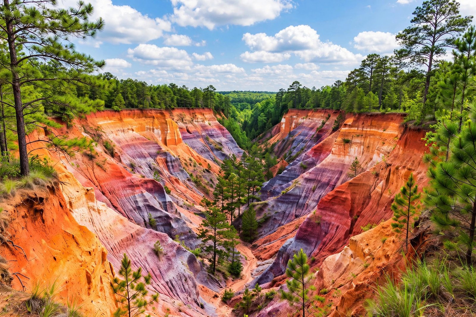
Drive southwest from Atlanta, past Columbus and into the quiet farmland of Stewart County, and the ground suddenly drops away. Pink, orange, purple and white cliffs rise out of a pine forest where, two hundred years ago, there was nothing but flat cotton fields. This is Providence Canyon, and it is one of the strangest and most beautiful places in Georgia. People call it the Little Grand Canyon, and the nickname fits the view, but almost nothing else about it fits what you expect a canyon to be.
What Is Providence Canyon?
Providence Canyon is a network of deep gullies in southwest Georgia, near the small town of Lumpkin in Stewart County, about 150 miles southwest of Atlanta. The park that protects it, Providence Canyon State Park, spans more than 1,000 acres. The canyon system itself covers several hundred acres of that land, and the largest canyon is about a half mile long, 300 feet wide and 150 feet deep, according to the historical marker at the site.
There are 16 canyons in all. Nine of them sit in the day-use area, where visitors can walk down to the canyon floor and between the walls. The rest lie in the backcountry, beyond the main trail loop. From the overlooks on the rim, the view is a maze of ridges, pinnacles and steep-sided gullies, all painted in bands of color. Down on the floor, the scale changes completely. The walls close in, the light turns warm and soft, and the striped layers tower overhead like the inside of a giant layer cake.
The park is operated by the Georgia Department of Natural Resources, and it is listed as one of the Seven Natural Wonders of Georgia.
How Bad Farming Carved a Canyon in Under 200 Years
The story of Providence Canyon starts with trees, or rather with the removal of them. When settlers arrived in this part of Georgia in the early 1800s, the land was covered in longleaf pine forest. The roots of those trees held together soft, sandy soil that had been laid down by ancient seas and streams tens of millions of years earlier. The soil was beautiful and fragile at the same time: rich in color, poor at holding together once it was exposed.
Settlers cleared the forest to plant cotton, the cash crop of the era. They plowed in straight rows, often running up and down slopes, and they paid little attention to soil conservation. Without tree roots to anchor it, and with furrows channeling rainwater into concentrated flows, the topsoil began to wash away. Small rills became ditches. The ditches became gullies. The gullies kept growing.
The speed of it shocked the people living there. Gullies were already being noted in the 1850s, and one early deed from 1836 documented the changing land. By 1850, some of the gullies were already three to five feet deep. That may not sound dramatic, but it was only the beginning. Once a gully starts, water funnels into it, cuts it deeper, and undercuts its sides, so the walls collapse and the channel widens. The process feeds on itself.
The canyon is named for Providence Methodist Church, built in the 1830s near what is now Canyon 2. The church had to be moved in 1859 because erosion was threatening to swallow it. Think about that for a moment: within a single generation, a farming mistake had eaten so much ground that a church had to be picked up and moved out of the way.
By the 1930s, the gullies had become deep cliffs, chasms and pinnacles, some of them more than 150 feet deep. The land was useless for farming by then, but it had become something else entirely: a landscape of extraordinary color and form, created by accident. Local people pushed for the area to become a national park. That did not happen, but in 1971 Georgia made it a state park instead, to protect the scenery and let visitors explore it safely. Governor Jimmy Carter signed the bill that year.
The erosion has not stopped. The canyon floor has now reached harder, more resistant layers, so the canyons are no longer getting much deeper, but they are still widening. Measurements taken between 1984 and 1994 found that between three and five feet of canyon wall was lost each year, mostly as the canyons grew wider rather than deeper. Visitors who return after several years often notice that the formations have visibly changed. Providence Canyon is still a work in progress, and every heavy rain reshapes it a little.
Why the Walls Show 43 Different Colors
The first thing most visitors notice, after the sheer depth, is the color. The walls of Providence Canyon are not one shade of red or brown. Geologists have counted up to 43 different shades in the canyon walls, from deep red and burnt orange to soft pink, lavender, purple, mustard yellow, pale gray and chalk white. On a bright afternoon, the colors seem to glow. After rain, they deepen and darken. At sunrise and sunset, the whole canyon warms to gold.
The colors come from minerals in the ancient sediment. The layers were deposited between about 59 and 74 million years ago, when this part of Georgia lay near the coast and was covered at different times by seas, streams, deltas and beaches. Each layer carries its own mineral signature. Iron oxides produce the reds, oranges and yellows. Manganese adds the purples and pinks. Kaolin, a fine white clay that is mined widely in Georgia, creates the chalky white bands. Limonite contributes yellows and tans.
Hiking the Canyon Loop Trail
The main hike at Providence Canyon is the Canyon Loop Trail, a white-blazed loop of about 2.5 miles that circles nine of the canyons and drops down to the canyon floor. The official trail map lists it at 2.45 miles and suggests allowing about two hours, with extra time to explore. Most visitors find that about right, though photographers and slow walkers should allow longer.
The usual route starts at the visitor center, follows the rim to an overlook, then descends into the canyons. Walking between the walls is the highlight. The trail winds from one canyon to the next, and each one has its own character: one is narrow and shadowed, the next opens into a wide amphitheater of color, the next has a towering pinnacle standing alone in the middle. You can walk right up to the walls and see the layers up close, the grains of sand, the small pebbles embedded in the clay, the places where groundwater seeps out and undercuts the base.
There are a few rules that matter more here than at most parks. Do not climb on the canyon walls, and do not climb on or over the fence lines at the overlooks. The soil is soft and crumbly, climbing damages the layered walls, and falls from these heights are dangerous. Stay on the designated trails, because every footstep off the trail compacts the soil or starts a new erosion channel. The canyon is still growing, and human feet can speed that up in the wrong places.
The Rim Trail offers a different view, looking down into the canyons from above, and it is the best option if you want panoramic photographs or if the canyon floor is too muddy for comfort. For experienced hikers, the Backcountry Trail is a 7-mile loop, marked with red blazes, that leads into the forested area beyond the main loop and offers primitive backcountry campsites by permit. It takes about six hours and is rated strenuous, so it is a full-day commitment rather than a casual add-on.
Trails close at 5:30 p.m. from September 15 through April 14, and 30 minutes before sunset during the rest of the year, so plan your start time with the closing time in mind. An afternoon arrival that leaves only an hour before closing is not enough to enjoy the loop properly.
The Rare Plumleaf Azalea
Providence Canyon is famous for its geology, but its most treasured living resident is a flower. The plumleaf azalea is a rare flowering shrub that grows only in southwest Georgia and east Alabama, and Providence Canyon hosts its largest known wild colony. The plant blooms in July through September, much later than most azaleas, which flower in spring. Its blossoms are a fiery orange-red, and they grow close to the watercourses far below the canyon rim, where the soil stays damp.
The Abandoned Cars at the Old Homestead
One of the most surprising sights at Providence Canyon has nothing to do with geology. Near the canyon floor, at the site of an old homestead, sit a cluster of rusting cars and trucks from the 1950s, abandoned decades ago and slowly being reclaimed by the forest. Their paint has faded, their tires are long gone, and vines and leaves have crept over their frames. They look like props from a movie set, but they are real, and they are a reminder that people lived and farmed here before the canyon swallowed their land.
Planning Your Visit
Providence Canyon State Park is at 8930 Canyon Road, Lumpkin, Georgia 31815, in Stewart County. It is an easy day trip from Columbus, which is roughly a half hour away, and a very doable day trip from Atlanta, about 150 miles to the northeast. The drive itself is pleasant, through small towns and farmland, and it sets the mood for a place that feels far from the city.
Allow at least two to three hours for the Canyon Loop Trail, plus time at the overlooks and the picnic area. If you want to add the Rim Trail or spend time photographing the colors, allow half a day. The park also has picnic sites and primitive campsites, so it works well as a slow, unhurried stop rather than a quick photo opportunity.
Why Providence Canyon Still Matters
Providence Canyon matters for two reasons, and they pull in opposite directions. The first is that it is a warning. It shows, in dramatic and permanent form, what happens when land is cleared without regard for soil. The farmers who created it did not set out to destroy their fields. They were doing what everyone around them was doing, planting the crop that paid, in the way that seemed normal at the time. Within a generation, their fields were gone. That is a lesson worth remembering every time we talk about land use, farming and conservation.
That is why people keep coming back to Providence Canyon. They come for the photographs, and they stay for the story. It is a story about Georgia, about farming, about geology and about time, and it is written in 150 feet of colored earth in a quiet corner of the state. Few hidden gems earn that description so completely.
Frequently Asked Questions
Where is Providence Canyon located?
Providence Canyon State Park is near Lumpkin in Stewart County, southwest Georgia, at 8930 Canyon Road, Lumpkin, GA 31815. It sits about 150 miles southwest of Atlanta and not far from Columbus and the Alabama state line.
How deep is Providence Canyon?
The deepest canyons reach up to 150 feet deep. The largest canyon is about a half mile long and 300 feet wide. There are 16 canyons in total, and nine of them are in the day-use area where visitors can hike.
Was Providence Canyon really caused by bad farming?
Yes. Settlers in the early 1800s cleared longleaf pine forest to plant cotton, which exposed soft, sandy soil to rain erosion. Gullies formed within a few decades and grew into canyons up to 150 feet deep in less than 200 years. It was not carved by a river over millions of years, the way the Grand Canyon was.
How long is the Canyon Loop Trail?
The Canyon Loop Trail is about 2.5 miles long, listed as 2.45 miles on the official trail map. It is a white-blazed loop that circles nine canyons and drops to the canyon floor. Allow about two hours, plus extra time to explore and take photographs.
When is the best time to visit Providence Canyon?
Spring and fall offer comfortable hiking weather and good light. Summer is the best time to see the rare plumleaf azalea in bloom, from July through September, though it is hot and the canyon floor can be muddy. Early morning and late afternoon give the best light for photography, when the colors in the canyon walls are at their most vivid.
Related reading
If you enjoyed this guide, keep exploring America’s most colorful landscapes with these guides from Trending 4: Antelope Canyon: Arizona’s Slot Canyon Guide, Great Sand Dunes National Park: Colorado’s Hidden Gem, and White Sands National Park: New Mexico’s Gypsum Dunes.
Sources and further reading: America’s State Parks: Providence Canyon State Park, U-Haul SuperGraphics: A Little Grand Canyon Existing in Georgia, Georgia State Parks: Providence Canyon State Park Trail Map, and Historical Marker Database: Providence Canyons Historical Marker.